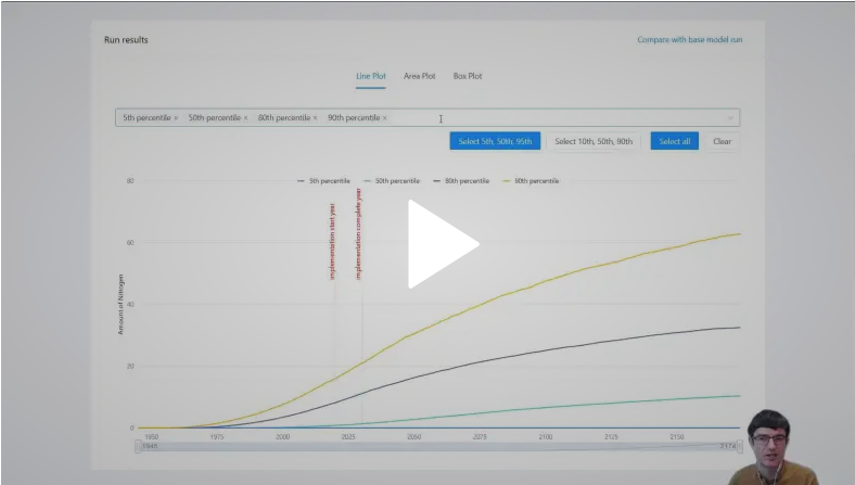
by Nick | Dec 17, 2020 | Talks and Presentations
I presented a work in progress decision support application for groundwater nitrate contamination based on changes in land use. This presentation was developed for the American Geophysical Union 2020 annual meeting. For more information on the lab this work was done...
by Nick | Jun 25, 2016 | Talks and Presentations
. In this presentation from the Society for Conservation GIS Conference in 2016, I presented on some of the work I’ve done at the Center for Watershed Sciences. I discuss PISCES, our software to manage, analyze, and display fish species range information, as...
by Nick | May 20, 2016 | Teaching
I’m the instructor for the Coursera Specialization in GIS. This video is one of many in a series that teaches the core concepts of projections and coordinate systems to students, to help them understand how we display and manage data about a (near-)sphere on a...
by Nick | Mar 26, 2016 | Teaching
I’m the instructor for the Coursera Specialization in GIS. This video is an introduction to the core concepts of databases with which users of GIS should be familiar. In the video, and the second video that continues the topic, I show how to design data tables...
by Nick | Feb 1, 2016 | Teaching
I’m the instructor for the Coursera Specialization in GIS. In this video, I showed the students how to use one of the core tools (and concepts) of GIS – and my personal favorite tool – the Spatial Join. See the rest of the course – Fundamentals...
